 |
Map of Ratchaprapa Dam
Khao Sok National park is one of the most valuable rainforests in Thailand. Ratchaprapa Dam was constructed in 1982 to preserve the water for electricity generator which creates over 100,000 rai of Cheaw Larn lake area.
The body of the lake creates the great impact to the wildlife both animals and trees. The impact from the sudden phenomenon create the lost among many specie inside Khlong Saeng and Khlong Ya sanctuary and also Khao Sok National park.
|
 |
| Type of possible cliff erosion |
Khao Luang geology consist of limestone base mountain . The uniqueness of landscape create the special appearance combine with the body of artificial water of Cheaw Larn lake create one of the most
attractive signature to the national park characteristic.
Before lunch the design on the cliff, the understanding of what happen under the ground is significant. Start with the origin of the cliff. The hypothetical cliff recession models show how the slope decline happened.
- The first possibility, an initial cliff gradually eroded in both slope angle and height because the parent rock has no internal structure to resist one plane erosion over another.
- Second, the force exist to cause mass wasting at the edge of the cliff only. No force exist to remove accumulated debris from the talus slope. Thus, the cliff height declines to zero over time.
- The movement of the bedrock create the rock fall which often involving caprock and the topple which involving undercut and collapse of both vertically and horizontally joint rock.
All type of erosion consist of force that take a million year to create one phenomenon which make these type of cliff strong enough to hold a structure that might install to the cliff.
To be more specific, the study over cliff ecology could be divided according to the specific characteristic on the surface.
: Each part of the cliff contain different characteristic :
- moorland : A large area of the land covered with grass, bushes, and heather which is the initial erosion in both slope and height also collect most windward side of the mountain.
- Mountain shoulder : The side of the hill or other solid structure that provides shelter from the wind. Multi-layered forest with an upper canopy and understorey is well developed in such site and almost entirely green.
- Mountain side : A slope covered with small pieces of rock and also the most protected part from the wind - support emergent trees up to 40 m high
- Sheltered (cliff base) : Collect small loose pieces of broken rock at the bottom of a cliff or along the slope of the mountain. The best part to collect water from the top-soil layer and the part that water start to scour into the bed rock.
- Summits : Steeply sloped accelerate erosion on the cliff face by breaking the platform into rock partical which are then driven into the cliff face.
- Brow : The highest part of the hill where the ground starts to became flat. Extremely expose to the sun and quickly lose rainfall to surface runoff or seepage through the porous rock.
 |
Cliff habitation typology diagram
A sparsely vegetated cliff or steep talus slope formed on the calcareous limestone or other moderately calcareous bedrock. The vegetation varies from sparse to patchy as the lack of soil and constant erosion restricts vegetation growth to rock crevices or soil pockets. Trees are typically present and may form woodland or even forest vegetation.
The species of animal are limit due to the vertically land that form type of living. The suitability of cliff faces as viable habitat for mammals is scale dependent. Small-scale cracks, ledges, crevices and the trees rooted within them provide ample opportunities for the movement of small mammal species such as rodents.
Despite the obvious difficulties imparted by the vertical orientation of cliffs, which select against large body weight and size, there are some larger mammal species for which cliff environments also provide optimal habitat.
Human use the cliff to experience one of the most challenge activity that could cost by life. Most of the climbing done in modern times is considered free climbing—climbing using one's own physical strength, with equipment used solely as protection and not as support—as opposed to aid climbing, the gear-dependent form of climbing that was dominant in the sport's earlier days. |
 |
Khao Luang rock climbing trail map example
Systems of ratings are inherently subjective in nature, and variation of difficulty can be seen between two climbs of the same grade. Hence, there may be occasional disagreements arising from physiological or stylistic differences among climbers.
The most commonly used rating systems in the United States are the Yosemite Decimal System and the Hueco V-scale bouldering grade. The current ranges for climbing routes are 5.0 for easy beginner routes to 5.15 . As the limit of human climbing ability has not yet been reached, neither grading system has a definite endpoint and is subject to revision. |
 |
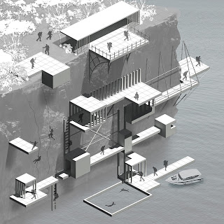
First draft of design project of cliff landscapes architecture
The target is to design the landscape architecture that could provide human the easier way the experience the extremely danger cliff wall and also being friendly to the existing nature. The design need to be able to constructed over the edge of the cliff and easy access by trekking ,from the ground surface or even from cave inside the cliff.
The architecture should be another way to getting to close to the nature of the edge which allow anyone to visit and let people get into the sense of the summit which not only thought the eyes but also through the soul. The minimum form that could touch the passion in human and lead to the appreciation that might be create from the architecture on the edge nature |


